

Lake of the Ozarks Weather Outlook Feb 5-11, 2018
Sunday's snowfall may be just the beginning. Lake of the Ozarks is starting off the week with a Hazardous Weather Outlook issued by the National Weather Service that calls for likely snowfall on Tuesday, and the chance for snow again at the end of the week. The advisory encompasses the Missouri Ozarks, including Camden, Miller and Morgan counties, as well as extreme southeast Kansas.
LakeExpo.com's Weather Radar and Extended Forecast
Monday: Primary concern is the extreme cold with temperatures this morning starting off at 0 degrees and wind chills reaching a dangerous -6. The area will see increasing clouds today and a high temp of 35, low around 20, with wind chill improving slightly at 11 degrees.
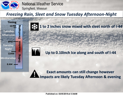
Tuesday: Mostly cloudy, high around 31, low 21. More snow and potentially sleet and ice are expected. Between noon and midnight areas north of I-44 could see an accumulation of 1"-3" of snow. Areas closer to I-44 may see more sleet and less accumulation. The National Weather Service notes that this storm system continues to change and more will be know by Monday night when it makes landfall on the West Coast.
Travel impacts are expected late Tuesday and Tuesday night. The peak period of impacts is expected to be Tuesday night into early Wednesday, but some impacts may be possible as late Tuesday afternoon over southeast Kansas and far southwest Missouri. Mostly snow is expected in west central and central Missouri where an inch or two is expected. A mix of sleet, snow, and freezing rain is expected farther south over southeast Kansas into southern Missouri where half an inch of snow and few hundredths to a quarter of an inch of ice is possible. The heaviest ice accumulation is expected over south central Missouri toward the West Plains, Eminence, and Alton areas.

Wednesday: Mostly sunny, high around 34 degrees, low 18.
Thursday: Mostly sunny, high around 46 degrees, low 31.
Friday: Partly sunny, high around 50 degrees, low 27.
Weekend Forecast
Potentials for rain and snow both days.
Saturday: Mostly cloudy, with a high around 37, low 22.
Sunday: Mostly cloudy, with a high around 40.


