
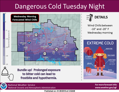
The Lake of the Ozarks area will feel the coldest temperatures of the winter this week, and meteorologists are warning Midwesterners to protect their homes and themselves from the bitter cold. A strong push of arctic air is expected to dip into the Midwest, including mid-Missouri, by mid-week. Strong wind gusts are expected to yield wind chills between -10 and -20 Tuesday evening through Wednesday.
According to AccuWeather Senior Meteorologist Mike Doll, "Some locations in the Midwest will be below zero continuously for 48-72 hours." The brunt of the cold will be felt further north, but Lake of the Ozarks will spend quite a while in single digits.
This extreme cold is thanks to a polar vortex, which is a whirling cone of cold air high up in the atmosphere that normally spins over the North Pole. However, sometimes a jet stream will push the vortex further into North America, causing incredibly cold temperatures. The bitter cold has already hit the Upper Midwest, with St. Paul, Minn. in the single digits and falling on Monday morning. Though temperatures in the Lake area are not expected to plunge quite as low as in Minnesota, we can expect on Wednesday to drop close to record temperatures of a high of 7 and a low of -7 that were set in 1966.
Lake of the Ozarks Polar Vortex Weather Forecast
Monday: Rain and snow are expected before noon with a chance of snow between noon and 1 p.m. with little to no accumulation expected. Chance of precipitation is 60%. High near 43 with temperatures falling to around 24 by 5 p.m. Wind chills are predicted to drop as low as 10. NW wind 10-17 mph, gusting up to 28 mph. Mostly cloudy night with a low near 12 and wind chills around 0. NW wind 9-17 mph, gusting up to 28 mph.
Wednesday: Flurries possible before 7 a.m. High around 10 with mostly sunny skies. NW wind 6-11 mph. Wednesday night expected to be mostly cloudy with a low near 5.
Thursday: Mostly cloudy with a high around 34. Thursday night expected to be mostly cloudy with a low near 28.


